
At Kodaikanal of 70 acre of land
(Dindugal -
District) Tamilnadu

Go to this Link You can further see the map details
http://wikimapia.org/#lat=10.2487086&lon=77.4865723&z=10&l=0&m=a&v=2
At Kodaikanal an altitude of 70 acre of land
(Dindugal -
District) Tamilnadu
Total area of land » 70 Acres
Location » Vathalakundu to kodaikanal Road Before
Kodaikanal 15 KM Near Perumalmalai Kodikanal
(Dindugal - District) Tamilnadu
Nearest railway station: : The nearest railway
station Kodaikanal Road (80 kms) is directly connected by rail with Chennai,
Nearest airport Madurai (120 kms from Kodaikanal
Price of this Total land is : Rs. 4.25Crore ( Four Crore
and twenty five Lakhs)
Road : 485km from Bangalore,520km from Chennai and 264km
from Ooty
Infrastructure
1. 70 Acres of Patta land with cleared Document
2. One Well (Never Dry)
3. 2 Private Falls (Never Dry)
4. Servant Quarters – 1 numbers
5. Very Beautiful View (Scenery View ) You can see Nature of God Beauty
Cultivation
The following plants are maintaining with good condition. at initial stage ( Cultivable
sources)
1. Pepper Plant
2. Cardamom Plant
3. Hills Banana
4. Coffee
5. Orange Tree
6. Butter Fruit
7. Fashion Fruit
8. Custard Apple
9. Citrus(Lemon)
10. Pomegranate
11. Kadukai
12. Jack Tree
15. More than 600 numbers of trees and plants are also there.
Important Information
You just maintain. You no need to apply fertilizer and
water that much of very good yield land. Year around you can get income.
Once the Coffee Season over then Jack fruit season come, then that season
over Orange season come. Once the that season our Hills Banana Season Start.
All the season over Pepper Season start. Carrot, Potato, So you can get year
around yield in this land. . Three
Phase Electricity available, Phone Facilities, Good road Facilities. Inside
the Land Water Falls available never dry in that falls year around water
come in that falls
Average income 3 to 4 Lakhs per acre for the year. Location before
Kodaikanal 15 KM (Perumalmalai). Immediate sales. If you want to visit this
land, you are welcome.
- Rs.
4 .25Crore ( Four Crore and twenty five Lakhs)
Note
: If you want Same type of land some what cheap means Per Acre 3- 15 Lakhs
available (Depends upon the Road, Distance,Yield method rate
will be differ) Good road facilities but after 5 to 15 KM from the earlier I mentioned
land. Don’t Late many farms lands here sold out. Kindly come and visit this
land . I am sure about it you like this type of land definitely. I am sure
about it. The view of the land is very wonderful Mountain scenery view.
If you want to see the Video of the Land
Kindly go to this link to see the photos of this Land
https://nandaconsultancy.tripod.com/Adugam_2.htm
|
|
 |


About Kodaikanal
From Wikipedia, the free encyclopedia
Kodaikanal (Tamil:
கோடைக்கானல்) is a
city[2]
in the hills of
Taluk division of
Dindigul district in the
state of
Tamil Nadu,
India. Kodaikanal
is referred to as the "Princess of
Hill
stations" and has a long history as a retreat and popular tourist
destination. It's a lot cooler in temperature than lower elevation cities such
as Chennai.
Kodaikanal was established in 1845 as a refuge from the high temperatures and
tropical diseases of the
plains.
[3]
Much of the local economy is based on the
Hospitality industry serving
tourism.
Etymology
-
It is not known who first used this name or what they intended it to mean.The
word Kodaikanal is formed from the two Tamil words Kodai and Kanal.
Kanal Kanal means seeing. By pronouncing with short tamil o as
Kodi, means Summer]]. Thus, Kodai Kanal means it is as good as
getting water in desert for summer heat .[4]
Another Tamil word for creepers is
Valli, the honey
collecting daughter of the chief of the Veddas mountain tribe. The chief and his
wife prayed to the Mountain God for a girl-child and their prayers were answered
when the chief found a new-born girl child during a hunting expedition. As she
was found among creeper plants, they named the child Valli and she grew up as
princess of the tribe in
Kurinji and became the consort of lord
Murugan.
[5]The
romantic traditions of Murugan in
Sangam literature are thus associated with the name Kodaikanal.
The Forest of Creepers was the
English language meaning given in 1885 during the early western habitation
of the place,[6]
and is still accepted.
[7]
History
-

1955 Topographic map of Kodaikanal
The earliest residents of Kodaikanal were the
Palaiyar tribal people. The earliest specific references to Kodaikanal and
the Palani Hills are found in Tamil
Sangam literature of the early Christian era.[8]
Modern Kodaikanal was established by American
Christian missionaries and
British bureaucrats in 1845, as a refuge from the high temperatures and
tropical diseases of the
plains.
[9]
In the 20th century a few elite Indians came to realise the value of this
enchanting hill station and started relocating here.[10]
Tourism has been impacted by industrial pollution issues including the
closure of a mercury factory owned by
Unilever's
Indian subsidary Hindustan Unilever after evidence of wide-spread mercury
pollution.[11]
To date no proper clean-up operation has been mounted.
Geography
The town of Kodaikanal sits on a
plateau above
the southern
escarpment
of the upper
Palni
Hills at 2,133 meters (6,998 ft), between the Parappar and Gundar Valleys.
These hills form the eastward spur of the
Western Ghats on the Western side of
South
India. It has an irregular basin as its heartland, the centre of which is
now
Kodaikanal Lake a 5 kilometers (3 mi) circumference manmade lake.
meadows and
grasslands
cover the hillsides. Gigantic Eucalyptus trees and
shola forests
flourish in the valleys. Mighty rocks and cascading streams. rise up from the
valleys. There are many cascading streams, high waterfalls and ubiquitous
gardens and flower beds in bloom.[10]
Neighbouring villages & towns
North of the town, high hills that slope down into the villages of Pallangi
and Vilpatti
stand guard. On the east the hill slopes less abruptly into the lower Palnis. A
precipitous
escarpment facing the
Cumbum Valley is on the south. On the west is a plateau leading to
Manjampatti Valley,
Indira Gandhi National Park, the
Anamalai Hills and the main body of the Western Ghats.
Economy
| Season |
Months |
| Peak Season |
April-June |
| Low Season |
Feb-March; July-September |
| Second Season |
October-January |
The economy of Kodaikanal is predominantly run by
tourism.[12]
The town's infrastructure changes every year in preparation for the peak tourist
season. Major roads are converted into one-way lanes to regulate the constant
inflow of traffic and special police are brought in for the safety of the
tourists and protection of local businesses. Hotels are often fully booked
during the high season, and remain virtually empty during the off-season. Due to
the rapid development of nearby cities such as
Madurai and
Coimbatore,
the town is starting to enjoy year-round tourism.
There are at least 50 hotels catering to all categories of tourists[13]
and over 30 south & north Indian, continental, western and Chinese restaurants,
and many more small eateries and tea stalls.
There are at least six
retail bank branches and five
automated teller machines (ATM) in Kodaikanal. The
Bank
of India has a branch and ATM at S.G.J Thangadurai Building, Anna Salai. The
Canara
Bank has a branch and ATM at CLS book shop complex, Anna Salai. The
Central Bank of India branch is at M M Street, Law's Ghat Road, Perumalmalai.
The
Indian Bank has a branch and ATM at Anna Salai. The
State Bank of India has a branch at Anna Salai and also has an ATM on Lake
Road, outside Kodaikanal International School
[14].
The
Union Bank of India has a branch at Naidupuram and also has an ATM on the
1st Floor of Municipal Shopping Complex opposite the Old Bus Stand, Anna Salai.[15],
[16]

Anna Salai, Street bazaar, with Mount Perumalmalai in distance
The Kodaikanal Co-operative Land Development Bank, The Kodaikanal
Co-operative Urban Bank at Anna Salai and the Madurai District Central
Co-operative Bank at Post Office Road offer only local
Commercial banking services.[17]
There is an excellent
bazaar where
residents, local villagers and tourists come buy woollen clothing, flowers,
fresh grocery, meat, handicrafts, hot snacks, cheap toys, medicinal herbs and
oils, hardware, dry goods and cooking fuels. The cosmopolitan nature of Kodai is
evident on Anna Salai, the main business street, where it is common to see local
villagers, European and American students and backpackers, foreign retirees and
families from other parts of India, all mixed together in their common activity
of shopping.
Plums, pears, chillies, carrots, cauliflower, cabbage, garlic and onions are
cultivated by
terrace farmers in surrounding villages.[18]
Most are trucked to other parts of India and some are sold in the local market.
Popular tourist souvenirs include handicrafts, home-made chocolates, postcards
and Eucalyptus oil.
[19]
Health
The two major medical facilities are the Van Allen Hospital and the
Government Hospital. These hospitals treat patients with common ailments and
injuries and perform child delivery and care, but are not equipped with modern
medical equipment for complicated diagnoses and surgeries.
In April 1915, Dr.Van Allen raised funds to construct the first unit of the
hospital at the entrance of Coaker's walk. It was named after him. Facilities
got updated from time to time and now it has X-ray machine, well equipped
pathological lab, and operation theatre with blood transfusion facilities. It's
working Hours are Monday to Friday : 9.30 to 11.30 a.m, 2.30 to 4.30 p.m,
Saturday : 9.30 to 11.30 a.m.
Government Hospital is situated on the hillside near Rock cottage on lower
shola road. It was a small municipal hospital until 1927. Now it has X-ray,
Dental, Maternity ward and other facilities.[20]
Air and water-borne
mercury emissions have contaminated large areas of Kodaikanal and
surrounding forests. A study conducted by the Department of Atomic Energy
confirmed that Kodaikanal Lake has been contaminated by mercury emissions.[21],
[22]
Education
Kodaikanal is renowned for the
Kodaikanal International School and the Kodaikanal Public School
[23]
The other schools are: St. Peters Matriculation Higher Secondary School
[24],
Zion Matriculation Higher Secondary School, Bhavan's Gandhi Vidyashram,
Brindavan Matric Higher secondary School, St. Joseph's Public School , St.
Xavier's High School and St. John's Girls Higher Secondary School.
The two colleges here are Kodaikanal Christian College and Sacred Heart
College. Mother Theresas University is distinctive as India's only university
devoted to exclusively women's issues.[25]
[26]
[27]
Recently a new engineering college specializing in
Information Technology, Kodaikanal Institute of Technology under
Anna University, has been established 22 kilometers (14 mi) below Kodaikanal
town. It has a 25 acres
(10.1 ha)
Wireless networked campus including of state-of-art Laboratories, Digital
Library & Learning Management System, 24/7 high-speed 8 Mbit/s Internet facility
and a Hostel.[28]
Religion

La Sallete Church
Since Kodaikanal was founded by the American and European
Missionaries,
Christian
churches are abundant in Kodaikanal. They include Church of South India -
opposite Bryant Park, Gorapur, Lake End, La Salette, Lutheran Mission, Sacred
Heart - Munjikal, Saint Antony’s - Antonyar Kovil street, Saint Francis Xavier,
Saint Joseph's, Saint Mary's and Saint Peter’s - Cockers Walk road. Amongst the
most popular is Union Church with a large Tamil congregation and Margaret Eddy
Memorial Chapel at Kodai International School with lively services in a
typically American style and distintive stone architecture.
There are many
Hindu Temples in Kodaikanal including the
Durgai Amman
Kovil, Kurinji Andavar Kovil,
Mariamman
Kovil, Observatory
Murugan Kovil
and
Vinayagar Kovil. The
Muslim
mosques are
Ellis Villa and Munjikal. There is an active community of
Tibetan
Buddhist refugees.
Civil society
Kodaikanal has several
clubs and
civil
society organizations operating for social, charitable and environmental
goals.

Kodaikanal Golf Club, Hole No.12, 256 Yards, Par 4
Established clubs in Kodaikanal are the Kodaikanal Lions Club (est. 1985)
under the jurisdiction of
Lions Clubs International (district 324B); Kodaikanal Boat Club
(est. 1890) with nearly 650 permanent members;
Kodaikanal Golf Club (est. 1895) with over 600 members and an 18 hole
golf course, spread over 143 acres (0.58 km2); and The Indian Club
(est. 1915) on Poet Thyagarajar road.[29]
In 1890, the Kodaikanal Missionary Union (KMU) was formed to enable
missionaries of the various demominations to come together for recreation and to
develop mission strategy and outreach in cooperation with each other. In 1923 it
built an
Edwardian style clubhouse with large central hall for social events and
afternoon teas, 6 tennis courts, a reading room, and other spaces for meetings.[30]
With the decline of missionary activity in India, the KMU was wound up in the
1980s, and the property was turned over to Kodaikanal International School. The
KMU library with many valuable old books besides newer materials, is still
functioning in one room, and provides something of a social venue. The valuable
original KMU archives materials have been incorporated into the archives of the
school, which has hired an archivist and is in process of converting the whole
original KMU building into an archives and display center for the school and the
community.[31]
(2008)

Kodaikanal lake View showing: Mount Perumal, Boat house, Carlton Hotel,
Kodaikanal International School, Fish hatchery, Lake Road.
Kodaikanal has several
Social service societies which promote local trade and increase employment
of rural villagers in the town's periphery by participating in its tourism
fueled growth. These include the Kodaikanal People Development Group (KOPDEG)
which has been successful in providing employment for marginalized women and
marketing their products. The Made-in-India tagged products from Kopedeg
are unique to Kodaikanal and are targeted at foreign tourists who regularly buy
them as souvenirs.[32]
The Cottage Crafts Shop at Anna Salai, is run by the voluntary
organisation, Coordinating Council for Social Concerns in Kodai (CORSOK).
They sell goods crafted by development groups and uses the commission charged to
help the needy.[19]
In 1994 the "Potter's Shed" was inaugurated. This pottery and craft Shop in
Kodaikanal has made and sold hundreds of thousands of fine pieces of locally
made pottery. All profits from this business are contributed to the Bethania
Kids, Center For Children with Disabilities.[33]
The Kodaikanal Lake Protection Council and Vattakkanal Organization for
Youth, Community and Environment (VOYCE) are active in preserving
Kodaikanal's environment. Plastic bags are banned and almost all shops and
roadside vendors heed the rule and use recycled paper bags in fear of a social
reprisal. Local hotels have also participated in improving the environment by
placing garbage cans all across the town, with their prominent donated by
signs acting as silent salesmen.[34]
Places of Interest

A waterfall enroute Kodaikanal
Kodaikanal has several scenic natural attractions which are enjoyed by its
visitors and make it a popular romantic destination for newlyweds. These are
described in order of distance from the bus-stand.
Kodaikanal Lake, 0.5 km (0.3 mi) from the bus stand, is an artificial,
roughly star-shaped 45 ha
(60 acres) lake built in 1863. It is recognized as Kodaikanal's most
popular geographic landmark and tourist attraction. Rowboats and
pedalos can be
hired at the Kodaikanal Boat Club with its main entrance near the only five-star
hotel in Kodaikanal, The Carlton. Horses and bicycles can be hired beside the
lake for short periods. The 5 kilometers (3 mi) path that skirts the periphery
of this lovely lake is a favourite walk for the locals and tourists alike.
Bryant Park, Just east of the lake and 0.5 km (0.3 mi) from the bus
stand, is a wonderfully maintained 20.5 acres
(8.3 ha)
botanical garden. The park was planned and built in 1908 by a forest officer
from Madurai, H.D.Bryant, and named after him. With 325 species of trees, shrubs
and cactuses, the park is a rainbow of stunning flowers during the peak season.
A large section is dedicated to nearly 740 varieties of roses. There is a 1857
Eucalyptus
tree and a
Bodhi tree which adds a religious significance to the park. Ornamental
plants are cultivated in a nursery for sale. The park organizes horticultural
exhibits and flower shows every summer, to coincide with the peak season.
Entrance fee to the park is nominal and it is open all year.[35]

View from Coaker's Walk

Bear shola falls
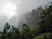
Pillar Rocks

Silver Cascade
Coaker's Walk, 0.5 km (0.3 mi) from the bus-stand, constructed by
Lt.Coaker in 1872, is a 1 kilometers (0.62 mi) paved pedestrian path running
along the edge of steep slopes on the southern side of Kodai. The walk, winding
around Mount Nebo, starts in front of the Van Allen hospital, running parallel
to the Van Allen Hospital Road and joins the main road beside St.Peter's Church,
providing a stunning panoramic view of the plains. On a clear day one can view
as far as Dolphin's Nose in south, the valley of the
Pambar
River in the southeast,
Periyakulam town and even the city of Madurai. A fascinating rare phenomenon
called
Brocken spectre can be witnessed, when a person can see his shadow on
the clouds with a rainbow halo. This occurs when the sun is behind the viewer
and clouds and mist are to the front. There is an observatory with a telescope
halfway along the walk. Entrance fee to the walkway is nominal and it is open
all year.[36]
Bear Shola Falls, 3 kilometers (2 mi) from the bus-stand, is a tall
waterfall in a
Reserve forest. The final approach to this quiet area is a gently climbing
foot-path.
Green Valley View, (formerly called Suicide Point) 5.5 kilometers
(3 mi) from the bus-stand and near the golf course, has an excellent panoramic
view of the plains and a sheer drop of 1,500 meters (4,921 ft) overlooking the
Vaigai Dam
to the south. The stairway leading up to it is highly commercialized and lined
with rows of shops to tempt tourists.[37]
Shenbaganur Museum of Natural History, 6 kilometers (4 mi) from the
bus-stand, founded in 1895, is open to the public for viewing their outstanding
taxidermy collection of more than 500 species of animals, birds and insects and
a living collection of over 300 exotic
orchid species. The museum is affliated with
Loyola College in Chennai and exhibits artifacts of the ancient
Palaiyar tribes people whose descendants still live in these hills.[38]
Kodaikanal Solar Observatory 6 kilometers (4 mi) from the bus-stand on
Observatory Road, at 2,343 meters (7,687 ft) is the highest location near Kodai.
The first observations were commenced here in 1901.[39]
Former Director
John
Evershed, discovered the phenomenon of radial motion in
sunspots, now known as the
Evershed effect. The Kodaikanal
Terrestrial Telescope can view a grand panorama including: Sothupparai Dam,
Vaigai Dam,
Periyakulam and Varaha river. This
Indian Institute of Astrophysics facility has a comprehensive
Astronomical
Science museum with organized public tours, access to the astronomy library,
and scheduled night-time telescopic sky viewing. It is open daily to the public
during peak season, and a few hours each Friday the rest of the year.[40]
Pillar Rocks, 8 kilometers (5 mi) from the bus-stand, is a set of
three giant rock pillars which stand 122 meters (400 ft) high.
[41]
Managed by the Tamil Nadu Forest Department, The viewpoint can be crowded but is
not commercialized. There is an excellent public garden adjacent to the
viewpoint.
Guna caves, made popular by the Tamil movie
Guna, previously
called Devil’s Kitchen, are deep bat-infested chambers between the three
gigantic boulders that are the Pillar Rocks. The deep narrow ravines of the
caves are now closed to public due to the trajic deaths of twelve youths there.[citation
needed] These dangerous caves are highly protected now, and
tourists can see sections of the cave system from afar.[42]
Silver Cascade, 8 kilometers (5 mi) from Kodaikanal at a wide bend in
the long and winding Laws Ghat Road, at altitude 1,800 meters (5,906 ft), is a
55 meters (180 ft) waterfall formed from the outflow of Kodaikanal Lake.[43]The
water quality is reportedly poor and not good enough for bathing.[44]
This impressive waterfall is a popular stop for first-time visitors. There are a
few souvenir and fruit vendors and many monkeys here. There is also a smaller
but more serene waterfall below the bridge which crosses the stream here.
Dolphin's Nose, 8 kilometers (5 mi) from the bus stand, is flat rock
projecting over a breathtaking chasm 6,600 feet (2,000 m) deep. It is an
undisturbed area 1 kilometers (1 mi) down a very steep rocky trail beginning
soon after Pambar Bridge. Orange juice vendors along the trail offer a welcome
rest stop. Beautiful views of steep rocky escarpments rising from the plains can
be seen. The old village of Vellagavi can be reached through a rugged bridle
path here. A short paved walkway leads from the road here to Pambar falls
(which is also locally addressed as 'Liril Falls' after the famous Liril Soap
Advertisement filming in 1985).
[45]
Kurinji Andavar Murugan temple, 4 kilometers (2 mi) from the
bus-stand, is famous for its
Kurinji flower which blossoms in the area only once every 12 years. The
deity here is called Sri Kurinji Easware, who is in fact Lord
Murugan. This
temple was built in 1936 by a European lady, who on coming to India, converted
to Hinduism. She changed her name to Leelavathi and married a Mr.Ramanathan. She
is also known as Lady Ramanathan. This temple is under the management of
Arulmighu Dhandayuthapani Swamy Thiru Kovil, Palani.[46]
Transport
Almost all distances from Kodaikanal are calculated with the lake as the
central point of reference. The nearest airports are
Madurai
(135 kilometers (84 mi)),
Trichy (200 kilometers (124 mi)) and
Coimbatore
(170 kilometers (106 mi)). The nearest Railway stations are
Palani Railway
Station (64 kilometers (40 mi)) north,
Kodai Road
Station (80 kilometers (50 mi)) south east and
Dindigul
Railway Junction (100 kilometers (62 mi)) east.[47]
The 2 - 3 hours drive to Kodai via the steep and winding
Ghat roads
from
Batlagundu or
Palani is a memorable experience. Travelers may stop at turnouts on the road
and enjoy the scenic beauty of the Palani hills.[48]
There is a 28 km shortcut from
Periyakulam to Kodaikanal via
Kumbakarai under construction. Bicycle rentals, taxis, vans and limited city
buses are available.[49]
Rickshaws are not available.[50]


